
Fugitive Emissions Abatement Simulation Toolkit (FEAST)
The Fugitive Emissions Abatement Simulation Toolkit or FEAST is a model to evaluate the effectiveness of methane leak detection and repair (LDAR) programs at oil and gas facilities. Recent advances in the development of new fixed (continuous monitoring systems) and mobile (truck-, drone-, plane-, and satellite-based) methane leak detection technologies have led to growing interest in alternative LDAR programs. The FEAST model helps operators and regulators compare a variety of LDAR program configurations such as continuous monitoring systems and hybrid aerial and ground surveys to develop cost-effective mitigation protocols.
FEAST Example Result
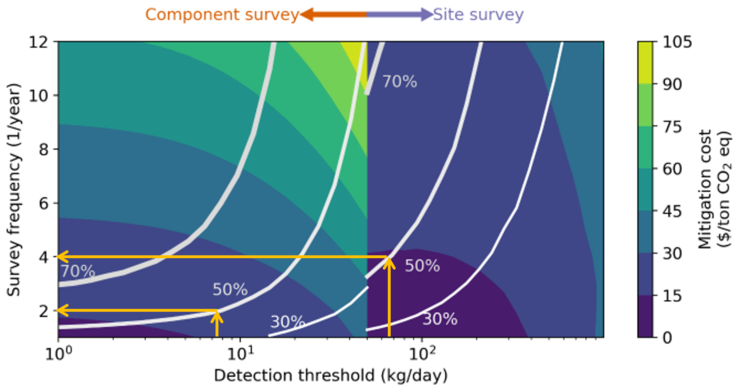
Example FEAST Result: Methane emissions reductions as a function of survey frequency (y-axis) and technology detection threshold (x-axis). White lines correspond to constant mitigation curves while the underlying color map represents mitigation cost in $/ton CO2eq. The yellow arrows show two different configurations of survey frequency and technology detection threshold that can achieve a 50% reduction in methane emissions (Adapted from: Kemp et al. (2021) Environ. Sci. Technol. 55 9140.)
The figure shows methane emissions reductions that can be achieved by choosing specific combinations of survey frequency (y-axis) and technology (x-axis). For example, to achieve 50% emissions reduction (as shown by yellow arrows), one can choose a semi-annual component-level survey with a technology that has a detection threshold of about 7 kg/d or a quarterly site-level survey with a technology that has a detection threshold of about 70 kg/d. The mitigation cost for the component-level survey is about $15-$30/ton CO2e, while that for the site-level survey is under $15/t CO2e. Thus, higher survey frequency can actually reduce mitigation cost if using the appropriate technology.
FEAST supports the following technologies and can model hybrid LDAR programs:
Optical gas imaging (OGI) camera
Aerial surveys (both equipment- and site-level surveys)
Drone surveys
Continuous monitoring systems
(To be available 6/22) Satellite-based detection
FEAST Resources
Link to FEAST version 3.1 GitHub codebase and repository (all code written in Python): FEAST Code
A public webinar was held on January 27, 2021 providing a high-level demonstration of FEAST 3.1 features and capabilities: Webinar Link
A public tutorial session on installation and running FEAST, including customizing simulation runs: Tutorial Link.
Publications
C. Kemp and A.P. Ravikumar (2021). New technologies can significantly reduce the cost of addressing methane emissions from the oil and gas industry. Environmental Science & Technology 55 9140.
C. Kemp, A.P. Ravikumar, and A.R. Brandt (2016). Comparing natural gas leakage detection technologies using an open-source virtual gas field simulator. Environmental Science & Technology 40 4546.
A.P. Ravikumar and A.R. Brandt (2017). Designing better methane mitigation policies: the challenge of distributed small sources in the natural gas sector. Environmental Research Letters 12 044023.
Xia, Strayer, Ravikumar - The Role of Emissions Size Distribution on the Efficacy of New Technologies to Reduce Methane Emissions from the Oil and Gas Sector
Strayer & Ravikumar - Role of Intermittency on the Effectiveness of Methane Emissions Detection at Oil and Gas Facilities: Comparative Assessment of Optical Gas Imaging and Site-wide Surveys